Lake Geneva Shore Path Access and Home Value: What Sellers Should Know
Quick answer: The Shore Path rarely costs a Geneva Lake seller money. Buyers here expect it, and the market priced it in generations ago. What does cost sellers money is handling it badly: an overgrown segment, unclear boundaries, or a disclosure gap that surfaces during the inspection period. Know exactly where the path crosses your parcel, maintain your section, and put the documentation in front of buyers early.
Sellers ask us some version of the same question every summer. Does the public walking through the lake-facing yard hurt what the house is worth?
Much less than you'd think. The way you handle it in the 30 days before listing absolutely can.
What the Shore Path actually is
A public footpath circling Geneva Lake, crossing the lake-facing yards of private homes, association beaches, and public parks as it goes.
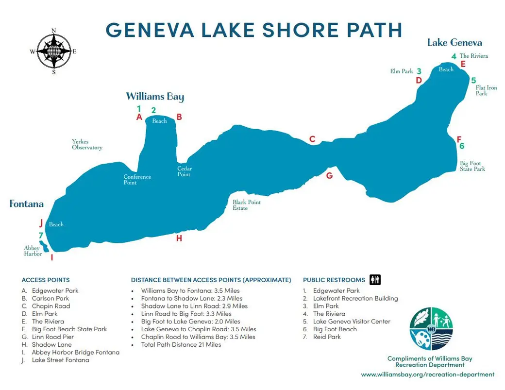
The Williams Bay Recreation Department map puts the total at approximately 21 miles. Other trail guides measure 21.4 to 21.9, and some accounts stretch toward 26 depending on how the route is traced. Twenty-one is the working number.
Surfaces change constantly: packed dirt, grass, limestone walkways, narrow footbridges, and uneven ground near private grounds. That variation exists because each owner maintains the section crossing their own property. No agency grades it, no uniform standard applies, and there's no shared budget. Your neighbor's flagstone ends and your grass begins.
The path predates the estates by a long way. Routes around this shoreline were in use by roughly 2,500 BC, and the Potawatomi lived along the lake until 1836. They knew it as Kishwauketoe, meaning clear water. The Chicago estate era came later, after the 1871 fire sent wealth north looking for summer ground.
Our covers the walking side: segments, parking, seasons, and where to eat afterward.
The details buyers ask about
Sellers get these questions on tours, and a vague answer costs you.
| Question | The answer |
|---|---|
| How long is it? | Approximately 21 miles |
| How many access points? | 10 official public access points, labeled A through J |
| Restrooms? | 7, all at access points, and they may be locked off-season |
| Can you bike it? | No. No bikes, strollers, or wheeled equipment of any kind |
| Dogs? | Yes, leashed, and owners clean up |
| Open in winter? | Yes, year-round |
| How long to walk the whole thing? | 7 to 10 hours, with about 446 feet of elevation gain |
The 10 access points run from Edgewater Park and Carlson Park in Williams Bay, through Chapin Road on the north shore, Elm Park and The Riviera near Lake Geneva, Big Foot Beach State Park, the Linn Road Pier, Shadow Lane on the south shore, and Abbey Harbor Bridge and Lake Street in Fontana.
The longest stretch between any two of them is about 3.5 miles.
Where your parcel sits matters more than the general history
Here's where sellers get into trouble. The general story about the path is not the same thing as the rights recorded against your specific parcel.
How the public's right runs across any one property varies. Some parcels have recorded easements. Some have plat language. Some rest on historic use. A few stretches divert onto neighborhood roads rather than following the shoreline.
Before you list, pull 3 things:
-
Your deed and title commitment, including any recorded easements from the Walworth County Register of Deeds
-
A current survey showing the ordinary high-water mark, the path location, setbacks, and any encroachments
-
Any prior DNR or municipal permits for piers, lifts, seawalls, or shoreline work
A survey is the single most useful document you can hand a buyer on a Shore Path property. It converts a question into a fact. Talk to a Wisconsin real estate attorney about what your parcel actually carries, because that answer is legal rather than editorial, and it differs house to house.
Your disclosure obligation comes first
Wisconsin requires a Real Estate Condition Report under Chapter 709 for most residential sales. It asks the seller directly about known conditions affecting the property, including boundary and encroachment issues and rights held by others.
Don't get creative here. If the path crosses your property and you know it, that's a known condition. Disclose it, attach the survey if you have one, and let the buyer read it early.
The practical reason matters as much as the legal one. A buyer who learns about the path from your disclosure packet on day 2 treats it as a feature of Geneva Lake ownership. A buyer who discovers it during a walk-through on day 20 treats it as something you hid, and that's where price renegotiations start.
The full packet is in . For your specific obligations, talk with a Wisconsin real estate attorney.
Does the path help or hurt value?
No published study isolates a Shore Path premium or discount on Geneva Lake, and anyone quoting you a percentage is guessing.
What we can say from working this market is that the path is part of what Geneva Lake ownership means. Buyers shopping lakefront know it exists before they tour, and it appears in nearly every lakefront comp, so it mostly cancels out of the analysis.
Where it moves the number is at the margins, usually through condition rather than the path itself:
-
A well-kept segment with a defined edge reads as a maintained property
-
An overgrown, eroded, or obstructed segment reads as deferred maintenance, and buyers price deferred maintenance high
-
Signage that reads as hostile to walkers puts buyers on alert about neighbor relations
-
Poor screening between the path and the main living space is a real privacy cost, and it does get priced
Our July 9 MLS pull covered 257 single-family sales across Lake Geneva, Fontana, and Williams Bay: median about $571,000, 99.7% of asking, 40 median days. Lakefront trades well above that figure, since it covers all single-family sales in the 3 markets. Pricing a Shore Path property means comparing it to other Shore Path properties, which is what a is for. Current figures are in the .
The maintenance question sellers get wrong
Your section is your responsibility, and buyers evaluate it the way they evaluate a deck or a seawall. By eye, and expensively.
What gets noticed: erosion at the edge, roots and washouts, a surface that's given out, drainage crossing the path, and any spot where the route isn't obvious. See for the rest of that first-minute evaluation.
Fix the path surface before photos rather than after an inspection. It's usually low-cost compared to what a buyer assumes it costs, and it's one of the better returns on the .
Worth checking with your insurance agent too: how your policy handles the public crossing your land. Confirm the coverage rather than assume it, and have the answer ready when a buyer asks.
Privacy is a design problem
Buyers who hesitate about the path are almost never objecting to the path itself. They're objecting to a specific sightline: the kitchen window, the patio, the primary bedroom.
Grade, distance, and planting decide it. A home on a rise with mature screening barely registers the traffic. A home at grade with an open lawn and a patio 15 feet off the path feels very different on a July Saturday.
If yours is the second kind, show buyers how it works rather than hoping they don't ask. Which side is the quiet side? What does the screening look like in leaf, and in April? A seller who answers in specifics has handled the objection. One who deflects has confirmed it.
What runs past your property is part of the pitch
On some stretches, the path is a genuine amenity you should be marketing rather than managing.
The north shore Snake Road section passes the Gilded Age estates: Wrigley Properties, Green Gables, Hillcroft, Flowerside Inn, and Wadsworth Hall. Black Point Estate anchors the south shore. Yerkes Observatory is visible from the path near Williams Bay, though it isn't accessible from it, which is worth knowing before you tell a buyer otherwise.
If your segment carries any of that, say so. A buyer choosing between two similar homes will take the one where the morning walk goes past something worth seeing.
For non-lakefront sellers, proximity is worth stating
Most homes in these markets aren't on the path, and this is the part sellers under-use.
Distance to a public access point is a marketable, verifiable fact. With 10 official access points around the lake, most properties in Lake Geneva, Williams Bay, Fontana, and Linn Township are closer to one than the owner realizes.
State it in miles or blocks. Don't imply rights the property doesn't carry, since buyers take the distinction between lakefront, deeded or association access, and nearby public access seriously. See .
One practical note for the buyers you'll be answering: the stretch around the Lake Geneva Public Library, about half a mile in either direction, is the smoothest and most accessible section of the entire route.
Community notes
Lake Geneva. The most foot traffic, and the paved library section. Access at Elm Park and The Riviera. Answer volume questions about your segment rather than the lake generally. See the and .
Williams Bay. North shore properties often sit above the water with long stair runs down to the path and pier. Document when those stairs were built or rebuilt. Access at Edgewater Park and Carlson Park. See and the .
Fontana. Two access points on the west end, at Abbey Harbor Bridge and Lake Street, plus Reid Park restrooms. Buyers here weigh path frontage against boat logistics at the same time. See and the .
Linn Township. The Linn Road Pier and Shadow Lane access the quieter south shore, with the lowest foot traffic on the lake and limited parking. If your property is on this stretch, that's a selling point worth naming.
The one-page sheet
Beyond the survey, deed, and permits above, add invoices for recent path, stair, or shoreline maintenance, plus your completed Real Estate Condition Report.
Then summarize it on one page and leave it on the counter. Buyers on a Geneva Lake tour are gathering answers to compare against 3 other properties that weekend, and yours is the one they can actually evaluate.
How Kim and Joel handle Shore Path properties
We start with the survey and title work, because the marketing can't be accurate until the boundaries are. Then we photograph the real relationship between house, path, and water rather than shooting angles that crop the path out. An image implying more privacy than the property carries doesn't survive the first showing.
Buyers researching the lake usually land on first, so they often arrive already understanding what the path is. That's an advantage. Our full process is in .
Frequently asked questions
Does the Shore Path lower the value of a Lake Geneva home?
Generally no. The path crosses most lakefront property on Geneva Lake, so it appears in nearly every comparable sale and largely cancels out of a pricing analysis. What does affect value is the condition of your segment, the screening between the path and your living space, and whether the boundaries are documented. No published study isolates a Shore Path premium or discount.
Do I have to disclose the Shore Path when selling?
Wisconsin's Real Estate Condition Report under Chapter 709 asks sellers about known conditions affecting the property, including encroachments and rights held by others. If the path crosses your property and you know it, disclose it and attach a survey if you have one. Ask a Wisconsin real estate attorney about your specific obligations.
Who maintains the Geneva Lake Shore Path?
Each property owner maintains the section crossing their own land, which is why the surface changes from grass to gravel to limestone as you walk. There's no shared budget or uniform standard. For sellers, that means your segment's condition is part of how buyers judge the property's overall maintenance.
Can I close off or reroute the path across my property?
Don't act on that assumption. The public's right to use the path is long-established, and how it applies to any individual parcel depends on recorded easements, plat language, and history specific to that property. Talk to a Wisconsin real estate attorney before making any change to the route or access across your land.
How long is the Shore Path and how many access points does it have?
Approximately 21 miles, per the Williams Bay Recreation Department map, with 10 official public access points labeled A through J. The longest stretch between access points is about 3.5 miles. There are 7 public restrooms, all at access points, and they may be locked off-season.
Should I mention the Shore Path in my listing if my home is not on it?
Yes, as a distance. With 10 access points around the lake, most properties in these communities are closer to one than the owner realizes, and stating how many blocks or miles is a specific, verifiable fact buyers value. Avoid any phrasing implying your property carries lake rights or path frontage it doesn't have.
Let's price your Shore Path property accurately
Selling a lakefront, lake-access, or near-lake home in Lake Geneva, Williams Bay, Fontana, Geneva National, Linn Township, or anywhere in the Lake Geneva area?
, start with a , or call or text (262) 325-9867
Categories
- All Blogs (205)
- Burlington Buyers Guide (1)
- Burlington Relocation Guide (3)
- Burlington Sellers Guide (1)
- Delavan Buyers Guide (1)
- Delavan Lake Sellers Guide (1)
- Delavan Real Estate Market Update (1)
- Delavan Relocation Guide (1)
- Delavan Sellers Guide (1)
- Elkhorn Buyers Guide (1)
- Elkhorn Relocation Guide (1)
- Elkhorn Sellers Guide (1)
- Fontana (13)
- Fontana Buyers Guide (1)
- Fontana Sellers Guide (1)
- Fontana WI Relocation Guide (2)
- Geneva National (5)
- Lake Geneva (29)
- Lake Geneva & The Southern Lakes Market Report (1)
- Lake Geneva Area Homes (10)
- Lake Geneva Buyers Guide (8)
- Lake Geneva Real Estate Market Update (6)
- Lake Geneva Sellers Guides (44)
- Lauderdale Lakes (2)
- Twin Lakes Buyers Guide (1)
- Twin Lakes Relocation Guide (3)
- Twin Lakes Sellers Guide (1)
- Walworth Buyers Guide (1)
- Walworth County Market Updates (5)
- Walworth County Seller Guides (6)
- Walworth Relocation Guide (3)
- Walworth Sellers Guide (1)
- Whats Happening at the Lake (30)
- Williams Bay (9)
- Williams Bay Real Estate Market Update (1)
- Williams Bay Relocation Guide (3)
- Williams Bay Sellers Guide (3)
Recent Posts